Through the Carriage Window – Industry along the Cumbrian Coast Railway
by Alan Postlethwaite
(Page created 11/02/18)
Ulverston’s first railway station (R.Baker, 2015)
Arnside The line we are taking was built for the Ulverstone & Lancaster Railway in 1856 and required crossings of two tidal river channels feeding into Morecambe Bay. Seen on the left leaving the station, the stubby pier was provided by the railway builders when the viaduct over the River Kent obstructed navigation to the wharf at Dixies. Constructed in 1857 in cast- and wrought-iron, the Kent Viaduct is 552 yds long and has 50 piers. The girders and decking were replaced in 1885 and in 1915 the whole viaduct was rebuilt by encasing the original cast-iron piers in stone and concrete. A completely new steel deck was installed in 2011.
Meathop. To the right, the low-lying land either side of Meathop Fell is reclaimed tidal marsh. Note the realigned Foulshaw Drain and channel of the River Winster. The seaward end of Meathop Fell was quarried for ballast and walling stone by the railway builders and later provided limestone to Carnforth ironworks. A gasworks to supply Grange was built where the railway crosses the River Winster and had a siding for the delivery of coal. Approaching Grange we pass on the left Holme Island where railway magnate Alexander Brogden resided at the time of the building of the railway.
Grange. The arrival of the railway spurred the growth of Grange from little more than a hamlet of 130 residents in 1851 to a small town with a population of 1,700 in 1881. The railway station of 1864 is a splendid example of the Lancaster Paley & Austin practice which was also responsible for the impressive Grange Hotel.
Kents Bank. This station sits at the western end of the crossing of the Sands from Hest Bank. The first station was so little used that it was soon closed. As the settlement grew a permanent station was erected.
Wraysholme. After leaving Kents Bank the line skirts the foot of the limestone outcrop of Kirkhead which is topped by a tower. To the left is the Humphrey Head promontary, traditionally regarded as the place of the killing of the last wolf in England and now a Nature Reserve. A spring that once issued from the limestone was thought to have curative properties for sufferers from lead poisoning and was visited by miners from Alston and Co. Durham. Wraysholme Tower on the right is a 15th century pele tower. Opposite on the coastal marsh, a railway siding was authorised in 1916 to the site of an intended airship factory for Vickers Ltd. The development was abandoned in 1917 and the site was later taken over for RAF Cark in WW2. For some years a narrow gauge track was here to assist construction of a new coastal protection embankment.
Cark. This station, which for many years was called Cark & Cartmel, serves the communities of Flookburgh, Cark and Holker. In its early days its significance was that it answered the transport needs of the Duke of Devonshire, Chairman of the Furness Railway Co., whose principal residence was Holker Hall.
Capeshead. Leaving Cark the railway skirts the Leven estuary with a prospect of Furness on the far shore and of the Hoad Monument above Ulverston. On the right hand side is the Holker estate and several expanses of fine arable land reclaimed from the sea by the railway embankment. The Leven Viaduct is the second major structure of the former Ulverstone & Lancaster Railway but was the first to be built, pioneering a jetting technique for sinking the piles. Work started on 1st April 1856. The viaduct is about 6ft shorter than the Kent crossing and consists of 49 spans. The original structure included an opening span to enable navigation to the port of Greenodd but this was removed at the 1885 redecking. Like the Kent Viaduct the piers of this viaduct were enclosed in brick and concrete in 1916. In 2006 the deck was renewed using offsite robotic welding techniques with the rails now secured by Pandrol resilient baseplates which isolate the bridge structure from high vibration levels and give a quieter ride.
Plumpton Jct. Leaving the viaduct we pass on the right the site of Leven Junction which gave trains from the south access to the Lakeside branch. This link went out of use in 1939 since when all Lakeside trains used the north- facing junction – the disconnected course of which can still be identified. On the left hand side is the site of Plumpton Jct signalbox which until 1971 controlled access to the Lakeside branch. Remains of iron mining are evident here. A branch line ran south from here and was originally intended to become an alternative route to Barrow avoiding the climb over Lindal bank. It never reached further than Conishead Priory but was used for freight services to Ulverston Ironworks, the Canal sidings and other industries at South Ulverston, including the modern Glaxo factory. Tracks were lifted in 2000 and the signalbox removed.
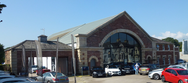
Ulverston. After crossing Ulverston Canal we reach Ulverston station, another Paley & Austin design of 1874. The unusual arrangement of an island platform was to facilitate the transfer of passengers to and from branch trains on the Lakeside service. The earlier Furness Railway terminus station is now a car showroom.
Lindal. Leaving Ulverston the line climbs steeply for two miles to a level summit at the former Lindal Ore Sidings. Here an extensive pattern of tracks was laid to enable the concentration of loads of haematite ore from local mines and the distribution of train loads of coke hauled from Co. Durham for the Furness ironworks. In its heyday this site boasted four signalboxes, a gasworks, an engine shed and an ore crushing mill. It had its own place in railway history as the spot where in October 1892 Furness Railway locomotive No. 115 disappeared for ever into an old mine working. As the line begins a descent towards Dalton the site of the former Lindal station is passed and the 340 yard Lindal tunnel entered.
Dalton. Entering Dalton we pass the site of Crooklands sidings: on the right was the original terminus of the Furness Railway where iron ore was loaded for carriage to the first shipping wharves at Barrow; on the left a branch line headed off to limestone quarries at Stainton. Once a through railway route to Whitehaven had been completed Dalton became a junction station and the line into Barrow was regarded as a branch off the main line. After passing through Dalton tunnel we reach Dalton Jct where the line to Whitehaven, now a goods only loop, bears right to meet the present Barrow to Whitehaven line less than a mile away at Park South.
Furness Abbey. Shortly after passing Dalton Jct the present line was joined from the right by the northern leg of the original Furness Railway which ran from Kirkby to carry slate from Burlington Quarries to the port of Barrow. A station at Furness Abbey served the Furness Railway’s Abbey Hotel and, before the loop line from Dalton Jct opened, was also the station where passengers changed for trains to Broughton, Millom and beyond.
Roose . Approaching Barrow we see on the right a scar on the hillside and the feint signs of rail trackbeds serving the former Yarlside mines. The lines followed a zig-zag route and continued over the hillside to reach the higher of the Stank mines. In 1868 John Barraclough Fell, the Greenodd timber merchant and railway engineer, used the Yarlside branch as the testbed for an experimental monorail which he hoped to sell to the Army for battlefield use. Roose station serves the southern parts of Barrow. We now pass vestiges of the town’s once extensive railway system. On the left a short-lived line once existed to take boat trains on to the Piel branch. Salthouse Jct was the main point of access to the Piel branch and also to the Stank branch. In later years these became sidings for the Roosecote power station and the Barrow gasworks. As our train bears right at the junction we see on the left the Ramsden Dock branch heading along the wall of the Cavendish Dock. This was once the main double-track route to the Barrow Town and Shipyard stations, marshalling yards, railway works, MPD, shipyard, ironworks, and docks but now is a single-line siding to the Barrow Marine Terminal where heavy nuclear fuel containers for BNFL Sellafield are transferred from rail to boat and vice versa. It also sees occasional use for loading wagons with crushed slate waste from Burlington quarry for land consolidation use at the Drigg LLW site.
Barrow in Furness. The station, once called Barrow Central, was the town’s third station and opened in 1882. It suffered severe bombing damage in May 1941 and reopened in its present form and with revised name in 1957. It stands on the Barrow loop line which placed the town on the through Cumbrian Coast route. Having more or less boxed the compass since leaving Dalton, we now head due north, passing on the left the carriage sidings and the remains of the ironworks’ slag banks which still dominate this part of the town.
Park South. Here we meet the northern end of the short connecting line from Dalton Jct with which there was once a triangular junction. The still active Goldmire quarry also at one time had a rail connection. Sidings at Park served the mines in the rich ore deposits on the left of our route which are evidenced by the large expanses of water filling the collapsed workings.
Askam. We pass Askam brickworks on the right, no longer rail connected, behind which are glimpses of the route of the railway that linked Mouzell iron mines to the Askam ironworks. This line crossed over our route to reach the ironworks which occupied the area on the left now covered by a modern housing development. When the railway was built Askam didn’t exist. The few early passenger trains called at Ireleth Gates Halt. As the new town grew Paley & Austin’s designed the present substantial station building in 1874. Leaving Askam there are traces on the left of the projected approach to the viaduct that was planned to cross the Duddon estuary from here to Millom. Although all the metal components had been delivered to Askam, in 1869 the decision was taken to abandon the project.
Kirkby in Furness. Here was the terminus of the northern leg of the original Furness Railway line and there was a long siding for the trans-shipment of slate which came down from the Duke of Devonshire’s Burlington quarry, high on the fellside to the right of the station, by a cable-worked incline. The station’s one claim to fame was that a seat set against the wall at the rear of the down platform was alleged to be the longest in the kingdom. In 1848 the Furness Railway extended its line from Kirkby to Broughton.
Foxfield. When built, the separate railway lines from Whitehaven and Barrow each terminated at Broughton. When the through route came into being Broughton was bypassed and a station was built at Foxfield. With the opening in 1859 of a new line from Broughton to Coniston, Foxfield became a junction station.
Green Road. On leaving Foxfield our line of travel makes another dramatic change of direction, from heading north to turning south along the northern side of the Duddon estuary. The original wooden viaduct over the river Duddon was subsequently rebuilt using some of the components intended for the abortive Askam to Millom project. The next station was at first called The Green but, together with another early station at Underhill closer to Millom, was closed due to lack of custom. Public pressure led to The Green station being reprieved. Along with several other stations on the Whitehaven & Furness Junction Railway it was at some distance from its closest settlement so the convention adopted by other railway companies was followed and the word Road was added to its title. It owes its relatively modern platform buildings to the demands on local transport facilities created by the influx of Service personnel into the Millom area during WW2.
Millom. Here we meet another example of the changes wrought by the deindustrialisation of recent times. Prior to 1968 an ironworks at Millom employed 650 men and occupied much of the land between the railway station and the estuary shore. Between the station and the works a network of tracks carried in supplies of coke and ore and took away the finished pig iron. Beyond the ironworks the railway lines continued to Borwick Rails, the former port for Millom, and on to the Hodbarrow iron mines, which prior to their abandonment in 1967, employed another 100 workers. Yet when the railway arrived in 1850 the local station was named Holborn Hill because Millom as a town didn’t exist. Part of the station buildings now house an excellent Discovery Centre that celebrates the town’s short but colourful story.
Silecroft. In the short distance to our next station we pass some examples of the cost of operating this section of the railway and also the reason that there is no Sunday service. At Kirksanton there are two manually controlled level crossings each of which needs to be manned by a signaller for the line to be open. Also at Silecroft the level crossing is operated manually from the signalbox as are those at Bootle and Drigg.
Bootle. Here is another station at some distance from the village from which it is named although the arrival of the railway generated its own local settlement. A WW2 ordnance factory at Hycemoor and HMS Macaw at Wellbank brought large flows of passengers here by rail. In 1945 a fire on a goods train carrying depth charges set off an explosion which killed the engine driver and blew away a section of the railway two miles south of Bootle.
Monk Moors. In 1897 Naval Construction & Armament Ltd, the then operators of Barrow Shipyard, established a Gun Testing Range on the shoreline near Eskmeals. A railway siding was laid in for the delivery of heavy naval gun mountings. Adjacent to the junction a wooden platform was erected on the main line for the use of workers employed on the Range. This was named Monk Moors and used only by authorised staff. On the landward side of the line here was a siding to which crushed granite was conveyed by an aerial bucket line from Broad Oak Quarry at Waberthwaite.
Eskmeals. Beside the viaduct over the estuary of the river Esk was Eskmeals public station which had no neighbouring population. Passenger services were withdrawn in 1959.
Ravenglass. This charming coastal community can boast of two handy railway stations – one on the national network and the other on the ‘Ratty’ – the Ravenglass & Eskdale Railway. Both enjoy a flourishing tourist trade. The main down platform houses the Ratty Arms restaurant and pub. The R&ER had its origins as a 3 ft gauge line built in 1873 to carry haematite ore from drift workings near Dalegarth down to the main line. This line had a fitful existence and in 1915 was converted into a narrow-gauge line from which the present ‘Ratty’ operation evolved. Between 1929 and 1953 dual-gauge track existed from Ravenglass to a stone-crushing plant at Murthwaite. Since BR discontinued freight services, the R&ER has occupied the former goods yard where it services its locomotives and rolling stock, radio-controls its trains from its signalling centre, has its ticket office, shop and café. The former main line Ravenglass signalbox is now preserved and can be visited. A museum and modern engineering building stand beside of the car park.
Drigg. This station is quite well situated for the small communities of Drigg, Stubble Green and Holmrook but probably owes its survival to the siting of a WW2 Royal Ordnance factory next to the railway line. In more recent times parts of the factory site have been adapted as a repository for contaminated waste from Sellafield and other UK nuclear facilities. North of the station a new access has been installed for the direct transfer by rail of contaminated material from the lengthy decommissioning project at Sellafield.
Seascale. The Furness Railway had ambitions to develop Seascale as a smart residential and holiday resort but their project didn’t advance much beyond the construction of the line of substantial villas north of the station. The railway did make the village popular for family day trips and Sunday School excursions from the West Cumberland towns. A café once occupied part of the down platform. The village gained a fresh purpose when in the 1950s it was developed with new housing for staff arriving to work at Calder Hall nuclear power station and its associated facilities. The FR’s ‘baronial’ water tower near the station has been restored.
Sellafield. The large industrial site formerly know as Windscale comes into view on the right as we pass Seascale golf course. When the W&FJR was built in 1849 there was no commercial justification for a station at Sellafield. After 1869 the line of the Whitehaven, Cleator & Egremont Railway was extended to meet the Furness line at a junction here. Going north the double track FR line divided from this point into two single track lines.
Braystones. From Sellafield our route now closely follows the coastline. We pass under a bridge carrying the sea discharge pipe from the BNFL plant and pass on the right a siding which is the rump of the former line to Whitehaven via Egremont and Moor Row. The level area on the right beside the River Ehen is the projected site for the new Moorside nuclear power station. A tiny station at Braystones serves the large caravan park but not all trains call here.
Nethertown. The railway now clings precariously to the edge of the friable boulder clay cliff. The station at Nethertown was vital for workers at the temporary camp located here during the initial work on the Sellafield site. In busier times there was a signalbox and passing loop to halve the seven mile section of single track between Sellafield and St Bees. The station now provides the only public transport for dwellers in the beach chalets and caravans. It has also seen use as a film location. Not all trains stop here.
St Bees. We approach St Bees past the golf course which once had its own Halt at which trains called. The signalbox here has always had an important role in regulating traffic over the single line south of Whitehaven with which is combined the complications of coping with road traffic on the level crossing on the village main street.