by Roger Baker

Along the coast from north to south – click on these headings to find out more.
Silloth and the Solway Firth
West Cumbria
Millom and the Duddon Estuary
Around Barrow-in-Furness
Ulverston and the Leven Estuary
Milnthorpe and the Kent Estuary
A number of places within striking distance of Carlisle acted as outports for the city at various times. Skinburness had the nearest shingle beach on which coasters could unload their cargo. Old Sandsfield on the River Eden was approachable by vessels of up to 60 tons burden. The trade was mainly imported timber, iron, flax, tar, rice and general goods, with a smaller export trade of wheat, butter and alabaster. Goods landed there were carted the remaining five miles into the city which added considerably to the cost. For example, the retorts and ironwork for the original gasworks in Carlisle (1819) were brought from a manufacturer in Liverpool to Sandsfield by schooner, and from there into the city at double the shipping costs. Similar restrictions applied across the river at Rockcliffe. Timber for the navy was exported from there in 1702 but was taken by sea only as far as Whitehaven for collection by a bigger vessel.
Port Carlisle (originally Fisher’s Cross) was the entry point for the Carlisle Canal, constructed in 1819-23 to enable sea-going vessels to reach the centre of the city. There was a jetty in the channel for steamers to Whitehaven, the Isle of Man, and Liverpool. The canal was replaced by the Port Carlisle Railway in 1854.
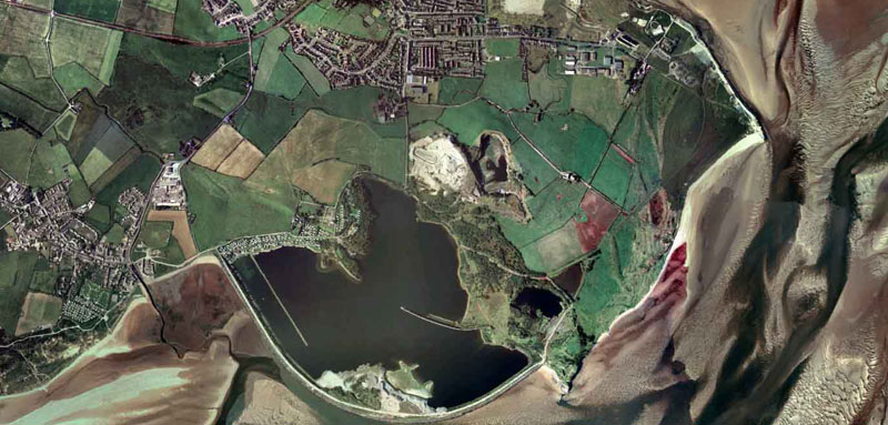
The first dock at Silloth (above) opened in 1859, the result of a continuing search for a port for Carlisle, and led to the development of the town by the Carlisle and Silloth Bay Railway and Dock Company. The dock was equipped with coal shutes, cattle lairages and hydraulic coal hoists in an attempt to break into the lucrative Irish trade. In 1880 the stone entrance wall of the dock collapsed and was rebuilt by the railway company; at the same time the inner dock was added. The original four acre dock is now the outer tidal harbour. The new dock could take vessels up to 2000 tons. The port handled a mix of coastal trade (cattle from Dublin, slate from North Wales, some coal to Ireland), and imports from further afield (grain from North America, Baltic timber, superphosphates from South America). The large flour mill founded by Carrs of Carlisle is the most prominent feature on the dockside.
To find out more:
The Carlisle Ship Canal, 1821-1853 : David Ramshaw, P3 Publications, 2013
Industrial Cumbria (in old picture postcards) : Bill Myers, European Library, 1993
The old port of Sandsfield : W T McIntyre, Transactions of the CWAAS 1943
The port of Carlisle : trade and shipping in Cumberland, 1675-1735 : Margaret Robinson, Trans. of the CWAAS, 2008
The port of Silloth 1859-2009 :Capt Chris Puxley, 2009
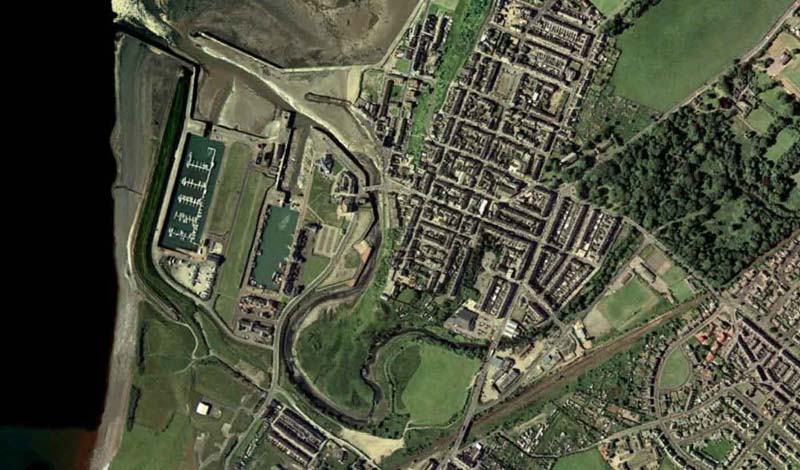
Maryport (above, right) was a new town founded by local landowner Humphrey Senhouse in 1748/9 around the development of the harbour at the mouth of the River Ellen, in order to break into the lucrative coal export trade to Ireland. South and North Quays on either side of the river were followed by the tidal Campbell or New Dock in 1836. Extensive development took place in the second half of the 19th century with the arrival of the railway, the Elizabeth Dock opening in 1857 followed by the six acre Senhouse Dock in 1884, both on land reclaimed from the sea. In 1867, 3000 vessels a year were using the port, with nearly half a million tons of coal exported in that year. These remained the largest docks on the West Cumbrian coastline until 1927, when the Prince of Wales Dock opened in Workington. Trade was principally exports of coal and iron products. Senhouse Dock was converted to a marina in 1989; a small fishing fleet remains.
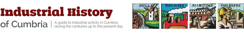
Workington (above, left) was loading coal for Ireland at the beginning of the 17th century. A wagonway from Seaton Colliery was opened in 1732, reaching the River Derwent at the downstream end of Low Cloffocks where coal hurries were constructed from which vessels were loaded. The Harbour Accounts of the 1730s show that there were buoys, marker posts, beacons, dredging work and new stone paving. These facilities were extended by a tidal cut of 1763-9. On the south side were a series of staithes linked by wagonways to local collieries . This was extended seawards by the Dock Quay of 1798, and the Merchants Quay on the other side of the cut. As the town’s iron and steel making industry grew in importance, the Lonsdale Dock was opened (1865) on land north of the river. This was enlarged and replaced as the Prince of Wales Dock (1927), which could take ships up to 10,000 tons. Click here to see photos.
The first quay at Harrington (above, right) was built for Henry Curwen in 1760, but the current harbour was constructed in the 19th century for the coal export trade (and iron rails for a while). The heyday of the port was in 1899 when 755 ships discharged and loaded 270,000 tons of cargo, especially coal to Ireland, lime to Scotland, timber from Quebec, rum and sugar from the West Indies.
Parton was a working harbour in the 17th century, ‘improved’ in the 1630s and ‘rebuilt’ in the 1670s despite legal action from the Lowthers of Whitehaven, shipping coal to Ireland from the Moresby colliery of William Fletcher.
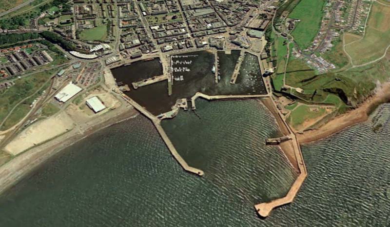
The small creek at Whitehaven (above, left) was enlarged to a harbour by Christopher Lowther in 1634. In the early 18th century the Lowther family sank coal mines and enlarged the harbour to facilitate export in locally built colliers. This led to the growth of shipbuilding yards building clippers for the Indies trade, and to Whitehaven becoming a centre for tobacco, spirits etc.. By the late 18th century, Whitehaven handled the fifth largest tonnage in Britain, 2153 ships of 224,934 tons sailing for Ireland in 1790, with a few others going elsewhere, chiefly to America, and about 25,000 tons going coastwise.
The harbour began as a number of stone quays:- The Old Quay (1634, but extended later) was followed by the Bulwark (1710), West Strand (1722), the Sugar Tongue (1733-5), New Quay (1742), and the Lime Tongue (1754). The main problem encountered with the harbour was silting, and Pow Beck was widened and deepened on many occasions. The harbour was further protected by the construction of the West Pier (1824/5) and North Pier (1833-41) to the design of Sir John Rennie. Wagons from local collieries used gravity on wagonways and inclines to reach the coal hurries some 50 feet above the harbour, from which vessels could then be loaded via shutes into their holds. This system could, when working to capacity, load eight or nine colliers with 500-600 wagon loads in a single day. Although a pier was built at Saltom Pit in 1732, it proved too exposed to be useful.
Queens Dock (1872-76) was built to support the coal and iron trade, but was more recently (from the1970s) used for the import of phosphate for the Marchon Chemical Works which reached a height of 500,000 tons a year. Rock silos and a conveyor system were constructed around three sides of the dock, with deliveries by road to the works. The restriction on the size of ships that could be accommodated was overcome for a time by the use of barges to offload bulk carriers anchored at sea.
The estuary at Ravenglass has provided a safe anchorage since early times for coastal vessels, with some trade in grain and cattle.
To find out more
Workington : Richard Byers, Tempus Publishing, 2004
Whitehaven : Alan W Routledge, Tempus 2002
Whitehaven Harbour : Brian Scott-Hindson, Phillimore, 1994
Marchon – the Whitehaven chemical works : Alan W Routledge, Tempus, 2005
Maryport : Keith Thompson, Tempus Publishing, 2000
Maryport – the passing years : John D Wells, The Author, 2006
Ships of West Cumberland : Desmond G.Sythes, Friends of Whitehaven Museum, 1996
The port of Ravenglass : C Caine, Transactions of the CWAAS, 1922
Harrington : Cumberland’s lost town : Richard Newman, Transactions of the CWAAS, 2008
Maryport Maritime Museum
The Beacon Musem, Whitehaven
Shipping lists from 1811 and 1840
The Parton project!
Solway shipping – past and present (especially Workington)
Photo gallery on this website of Workington Docks
Around Millom there was a local coasting trade in coal, iron and slate through the small harbour at Borwick Rails (above, top right), the creek at Haverigg (bottom left), and the beaches at Hodbarrow Point (centre). The discovery of large quantities of iron ore led to a huge increase in shipments out of the area from the Hodbarrow Mining Company’s pier at Crab Marsh Point (Borwick Rails), with almost 600 vessels using it in 1864.The ironworks of the Cumberland Mining & Smelting Company Limited began production in 1867, and in the following year started to build their own pier at Borwick Rails, only a stone’s throw from the mining company’s pier. Millom Pier grew to be nearly half a mile long, and included the original harbour. On one day in January 1892, eight steam vessels shipped 4400 tons of ore from the mines. The last shipment took place in 1940, and the pier was derelict by 1951.
On the other side of the estuary at Kirkby-in-Furness, slate from what later became the Burlington Quarries was loaded into flat bottomed boats called “dolly flats” at the quayside near Sandside Quarry. The boats were guided across the estuary and the slate loaded into sloops at Haverigg and Millom. It seems reasonably certain that sloops loaded and sailed directly from Sandside when the tides were favourable. As quarrying expanded inland, slate was conveyed in small four-wheeled wagons on iron rails down an incline to the wharf.
Iron ore was brought to, and iron sent away from, Duddon Furnace (built 1737-8) via Lady Hall Marsh, being carted roughly a mile from there to the storehouses at the furnace.
To find out more
Millom, a Victorian new town : Alan Harris, Transactions of the CWAAS, 1966
Burlington Blue-Grey : R.Stanley Geddes, The Author, 1975
Bygone folk and industries of the Duddon Valley : G.K.Stebbens, The Author, 2002
Millom Folk Museum
Piel Island was used as a transhipment point by Furness Abbey. The 14th century castle was probably intended to be used as a fortified warehouse to keep cargoes safe from pirates and other raiders (and the customs men). Customs House built in the 1700s (later transferred to Ulverston). Houses for pilots in late 18th century.
Roa Island was linked to the mainland by embankment in the 1840s, as part of the Fleetwood to Furness section of the London to Glasgow rail route. Pier later used for summer sailings for tourist traffic.
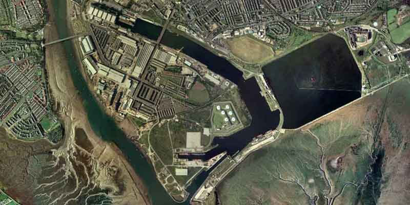
The Newland Company built the first jetty into the Barrow channel in 1782 for loading ships with iron ore. Others followed as iron ore exports rose from 1200 tons in 1800 to 146,000 tons in 1849. Peaked in the 1850s as more and more was used locally, then gradually replaced by imports of foreign ore, rising from 30,000 tons per annum in the 1880s to 571,414 tons in 1918 and a peak of 1,155,076 tons in 1956. Other exports during this period were pig iron, steel rails and machinery; with imports of coal, petrol, timber and grain (Barrow Corn Mills completed 1871, closed 1967).
Development of the port began in earnest in 1854 when plans were adopted to enclose the channel between the town and Barrow Island to create a huge dock system – Devonshire Dock (1867), Graving Dock (1872), Buccleugh Dock (1873), Ramsden Dock (1879) and Cavendish Dock (1879) – see photo above. The latter never had access to the channel, but served as a “feeder” for the other docks, as a timber pound, and more recently as the cooling pond for the nearby Roosecote power station).
Ambitious plans to rival Liverpool as a port never took off, although attempts were made. For instance, extensive cattle sheds were built in 1879 to foster a live cattle trade between Barrow and the United States, but this trade never repaid the considerable expenditure. The southern parts of both the Devonshire and Buccleugh Docks were given over to the shipbuilding and fitting business of Vickers (now BAE).
Click here to read more about the Port of Barrow.
To find out more:
Barrow and District : F Barnes, Barrow in Furness Library & Museum Committee, 1978
The Furness Railway in and around Barrow : Michael Andrews, Cumbrian Railways Association, 2003
Half a century and more of ship photography at Barrow : Ken Royall, World Ship Society, 2017
Barrow’s Dock Museum (built over and in part of the graving dock)
ULVERSTON AND THE LEVEN ESTUARY
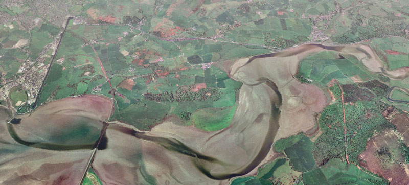
The Leven Estuary had a number of shipping points during the 18th century, at Penny Bridge and Greenodd (before being cut off by road and rail bridges), at Plumpton and Hammerside Hill near Ulverston, and further along the estuary, for example at Conishead Bank and at Beanwell near Baycliff. The latter were two of the “mine floors” which were dotted around the coast of Furness and to which iron ore was carted from the mines inland to be dumped and then loaded into small coasting vessels for delivery to the furnaces (at Backbarrow for example).
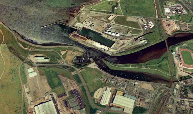
Ulverston‘s (above, left) coastal trade stimulated thoughts of an outlet which did not rely on tides, and the result was the Ulverston Canal connecting the town with the estuary. There were early problems, notably a shift in the channel away from the canal entrance, which led to the construction of Collins Weir from the opposite bank to divert the channel back to where it was needed. It is recorded that the peak year for traffic on the canal was 1846, with around 944 vessels arriving and departing. Imports included bricks, coal in large quantities, charcoal, cotton, flour, grain, iron, timber and ale. Exports were baskets, brooms, cotton yarn, pig iron, limestone, malt, gunpowder and slate. The arrival of the railway contributed to its demise; the ironworks and quarries used their own jetties outside the canal; cargoes were still discharged and loaded directly from the sands; and Barrow grew as a deep water port. Fewer than 400 vessels used the canal in 1848, and its traffic steadily declined. The last ship left Canal Foot in 1916.
Ulverston had taken much trade away from Greenodd (above, top right), which continued to ship copper ore, lead, slate, woodland produce and gunpowder from quays along the River Crake until 1869 and the building of the Lakeside branch railway which cut off access to the river from the estuary. There were six quays downstream of the new turnpike bridge of 1820. The first of these was owned by J.B.Fell and had on it a steam-powered sawmill and a slipway for building coasters of 30-100 tons. The port handled 24,000 tons p.a. in the 1840s, and featured a daily steamship service to Liverpool. Navigation up and down the estuary was maintained through a 30 foot drawbridge when the Leven Viaduct for the Ulverstone and Lancaster Railway was opened in 1857, but the traders of Greenodd agreed to exchange that facility for a branch line to the village, thus sealing the fate of the port. Greenodd itself had only developed as a port when the new turnpike bridge of 1820 closed the river for navigation further upstream to Pennybridge.
To find out more:
Early iron industry of Furness : A Fell, Hume Kitchen, 1908
Furness iron : Mark Bowden (ed.) : English Heritage, 2000
Ulverston Canal and the construction of Collins Weir : Jack Layfield, Finger Prints , 2007
The industrial archaeology of South Ulverston : Rob McKeever & Jack Layfield, R McKeever, 2004
John Barraclough Fell : A N Rigg, Hewitson and Harker, 1996
The Ulverstone and Lancaster Railway : Leslie R Gilpin, Cumbrian Railways Association, 2008
MILNTHORPE AND THE KENT ESTUARY
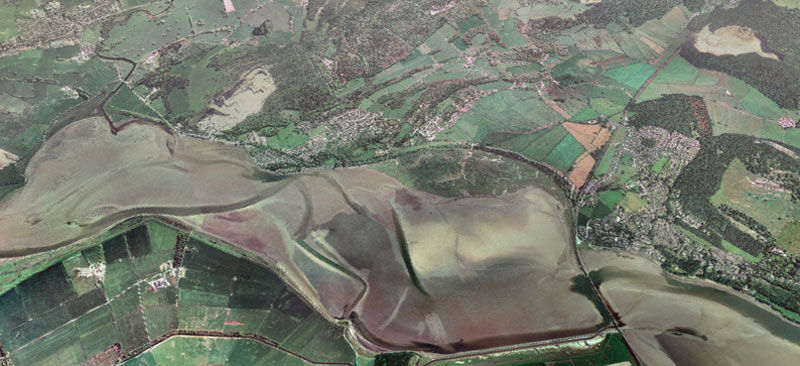
Until the early 1800s ships could sail on the tide up the River Bela as far as the old bridge (1730) or its 16th century predecessor in Milnthorpe (above, upper left), Westmorland’s only sea port and the outlet for the industries of Kendal. There were no wharves, ships would settle and be propped up in the river and unload to the banks across planks. Imports included coal, salt, pig iron and grain, with an export trade in gunpowder, agricultural products and textiles. The opening of the Lancaster Canal (1819) dealt a blow to the port, especially the trade with Kendal, and the opening of the New (road) Bridge in 1813 cut off access to the town. Trade moved down the estuary to Sandside (above, centre) which had a few wooden jetties, although many ships were beached on the tide and their cargo unloaded in carts. Before long, however, this part of the estuary was cut off by the construction of the viaduct (1857) across the Kent at Arnside for the then Ulverstone and Lancaster Railway. A stone jetty was built there by way of compensation, but Arnside (above, right) was better known for fishing and pleasure trips (by sail and steam), and shipbuilding rather than shipping.
To find out more:
The port of Milnthorpe : W T McIntyre, Transactions of the CWAAS, 1936
The chronicles of Milnthorpe : Roger Bingham, Cicerone Press, 1987
Kendal’s port (The creek of Milnthorpe) : Leonard Smith, Lensden Publishing, 2009
GENERAL SOURCES
Through mighty seas (website) – merchant sailing ships of the NW of England
A history of Cumberland & Westmorland : William Rollinson, Phillimore, 1996
Industrial archaeology of the Lake Counties : Michael Davies-Shiel and J.D.Marshall : David & Charles, 1969
A guide to the industrial archaeology of Cumbria : John & Jan Bennett (eds.) : Association for Industrial Archaeology, 1993
The appointment of ports in Cumberland : R C Jarvis, Transactions of the CWAAS, 1947
The history and archaeology of ports : Gordon Jackson, World’s Work, 1983
(Page created 17/11/07. Last updated 05/04/20)